
As well as looking at small rocks close-up, I’ve been looking more widely at the geological formation of a landscape, in particular topology, and how that is expressed through cartographic contour lines. I find it interesting how uniquely a particular area is described by its topology; it’s almost like taking a fingerprint of the landscape. Giuseppe Penone, Antony Goldsworthy and Bryan Nash Gill all have work that explores fingerprints/can be linked to this idea of a unique identifying pattern:

Image from https://twitter.com/londonisyours/status/778978166228525057 
Image from https://www.mariangoodman.com/artists/58-giuseppe-penone/works/11830/ 
Image from https://www.pinterest.co.uk/pin/529384131185173565/

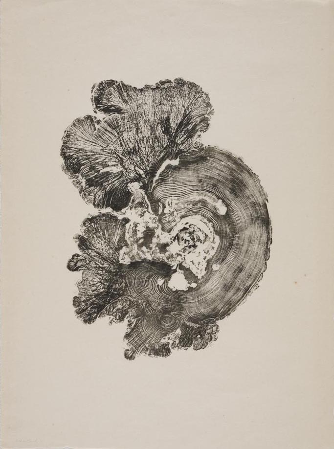
Cedar Burl – Image from http://www.bryannashgill.com/woodcuts#/woodcuts/cedar-burl 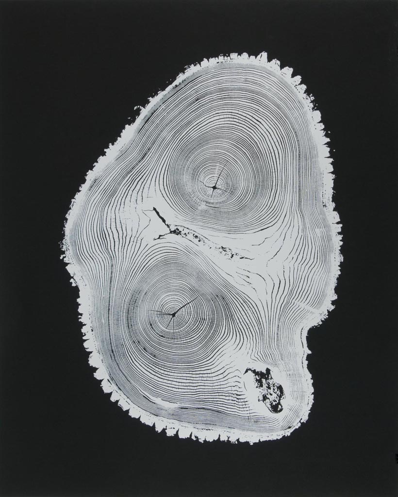
Leader – Image from http://www.bryannashgill.com/woodcuts#/woodcuts/leader-0173 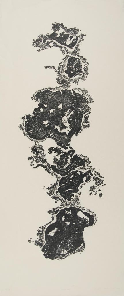
Rolling Burl – Image from http://www.bryannashgill.com/woodcuts#/woodcuts/rolling-burl
Penone’s work literally stems out from his fingerprint, almost creating its own unique landscape based on his biology. Gill’s work is less directly related to fingerprints, but the idea of taking a cross-section that can only ever be attributed to one tree is very similar. His work is described as being a form of monument/memorial to the tree, immortalising the details of the tree’s lifespan for all to see. This relates to the work of Otobong Nkanga, who describes abandoned mining pits as a form of “negative monument”. (The idea of giving the natural world recognisable fingerprints draws obvious parallels between humans and nature, which links to this article I read recently – https://www.theguardian.com/books/2019/nov/02/trees-have-rights-too-robert-macfarlane-on-the-new-laws-of-nature.)
I personally have started experimenting with using contour lines as a way of taking a fingerprint of a landscape, making a unique documentation of a particular area. I bought an old map with interesting sections of contour lines – one part in particular looks almost like a section of gnarled wood – and literally just traced them as a way of isolating them from the landscape. It was surprisingly time-consuming and particularly difficult to pick out in areas of dense civilisation, but the result was almost entirely accurate which I feel is an important element of the piece. It would be interesting to see if contour-only maps existed as this would make the whole process a lot easier, or could even just be exhibited in themselves, alongside other elements from the landscape.
The location I chose for this particular one was entirely arbitrary, but perhaps for future I could consider this idea of combining the drawings with other physical artefacts from the same location. The contour lines of heavily mined sites in particular could be very interesting, and presented alongside other objects could link in with this idea of a monument to a landscape. It would be good to develop this on a larger scale than A4, and potentially exploring other media? Etching would get a good fine line, or even engraving could be a link to the historical scientific nature of mapping? (contour only maps: http://maps.digimap.gg/GeographicalMap/, try Digimap?, download OS Terrain software?)

Section of tracing paper 
Section of tracing paper 
Section of tracing paper 
Transferred contour lines 
Transferred contour lines 
Digitally inverted contour lines 
Digitally inverted contour lines 
Shaded contour lines 
Shaded contour lines 
Digitally inverted shaded contour lines 
Digitally inverted shaded contour lines 
Digitally inverted shaded contour lines
The pieces exist as reflected versions of each other due to the way I traced and transferred, which introduces an unexpected potential aspect of symmetry. I recently went to an artist talk by Peter Randall-Page whose work explores the balance between pattern formation and random variation in the natural world; he often uses symmetry in his work as our natural ability to interpret/read faces means we are intuitively tuned to it (link to the work of Rorschach). I made a symmetrical version based off this, but at the moment other than an exploration of abstract pattern formation I am unsure as to any conceptual developments I could make from this.


The very slight, almost unnoticeable, difference between the tracings and the transferred pieces could also be an interesting avenue to explore. Tracing the same piece repetitively could become representative of the small, subtle changes that occur to the geology of a landscape over time that go unnoticed on a day-to-day level, or even over lifetimes – a look into accessing the deep time movement of rock. This could then be contrasted with the drastic, rapid changes that humans can have on a landscape, such as the “negative monuments” of Nkanga’s mined landscapes. I also was recently looking at Hiroshi Sugimoto’s Seascapes. He says that he creates these images of purely sea and sky as a way of connecting with ‘the ancients’ – this is a shared scenery with those who lived thousands of years ago ‘when humans were just starting to be conscious of being human’. Looking at the bare geological bones of a landscape shares this same idea, and this again links to a sense of deep time, a concept that is perhaps needed to ‘revert us to our innocent minds in the face of unstoppable capitalism’ and ‘gives us an opportunity to stop and think before destroying ourselves’. (Rachel Sussman‘s work also explores this idea of deep time in relation to the current climate crisis)

The shaded pieces refer more strongly back to the initial three dimensional nature of the information, giving a slight sense of peaks and troughs, although still not particularly representational. In a recent studio session with Simon Averill we looked at the way some artists will move between two and three dimensions, and what this interplay can bring to a work (for example http://www.karinschaefer.com/). (I also have partly explored this idea through my rocks – collecting specimens, drawing them and then sculpting them). I could consider taking the piece back to three dimensions, perhaps through a similar technique to the paper rocks, although this could be a bit counter-productive to move directly from three to two to three directions without much alteration between steps.
A couple of other observations I made were:
- the shading has the added effect of being suggestive of rock striations/geological variations
- there is a lack of scale: while the piece is relatively obviously some kind of contour lines, it could be interpreted as something on a much smaller scale, such as tree rings/patterns
I found it interesting how the contour lines interacted, as it were, with the rest of the features on the map which were predominantly man-made. I have previously explored (last year on Foundation) the parallels in growth patterns between man spreading out over a landscape and, for example, bacteria growing; this work somewhat links to that in a sense of how the land influences the way in which civilisation spreads. It could also be interesting to look at areas where the opposite is true: where man has physically made the contours, such as mines and quarries.
Potentially I could also link this idea to the practice of walking. As I drew the pen across the page following one contour line it would often roam randomly through areas of civilisation, bisecting roads and rivers, then wander out into the open and so on. This could be used as the path of a walk, perhaps linking to the idea of taking a random snapshot of the world, uninfluenced by the choices of the artist, like the Boyle Family.


Above I have included some process shots, as well as some images of stages I found had potential for further development. There’s some pictures of sections of the geological map at CSM which I feel shares similar themes of creating a unique ‘fingerprint’ of the land, and has potential for further exploration. I also found it visually exciting when I had layers of tracing paper over one another – perhaps I could have different contour heights on different layers and then stack them all together? This would give a sense of the 3D nature whilst still being ultimately 2D, or I could even begin to link this to my stacked paper rocks? Alternately, I could trace the human population elements of the map and have this as a separate layer, as a way of exploring this link between the growth of the population and the landscape.
In all, this started out as just a quick exploration of some visually intriguing elements of a map, but over the time it’s taken me to produce them I’ve been able to read in more to what they could represent. I obviously have to be careful to not read in too deeply to what is essentially just a copy of some contour lines, but there are definitely some themes that have emerged that the piece explores well, and that I could continue to investigate leading on from this. The idea of taking a ‘fingerprint’ of a particular landscape, perhaps in some way as a monument to it, is one of these, as well as potentially how the landscape is changing over time. This idea of change links well to the paper rocks I have been creating, and also could link into how human population growth interacts with/can physically impact the landscape.
